


介绍 V-Navi
V-Navi - The full-featured navigation app for Android that brings you quicker to your goal! Works in conjuction with various apps (e.g., "Das Telefonbuch", "Das Örtliche", among others), even free of charge, as conditions may apply.
ATTENTION: Navigation can be started in Germany, Austria, Switzerland and optional in Western Europe.
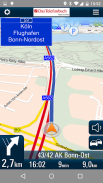
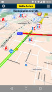
With the high quality traffic you will get a complete overview of the market. Traffic congestion traffic congestion avoidance. The V-Navi: you will thus always the best route. The traffic density is displayed in red, yellow, green in the map. Germany, Annual, 30 days free of charge with no obligation to buy. Internet connection is required.
The new version of V-Navi works with offboard maps (with limited functionality) to enable immediate navigation after download. The map data for Germany, Austria and Switzerland is downloaded once at the start of the first use of V-Navi (ca. 300 MB). Thereafter, an Internet connection is only necessary for a short time at app-startup.
HIGHLIGHTS:
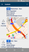
- Current traffic situation in Germany (INRIX), traffic reports traffic congestion avoidance and traffic density display
- Offboard vector mode after first installation
- Lane info assistant
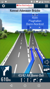
- Reality view (reality like display of turn actions on motorways)
- Map data is stored on the device
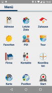
- Quick destination entry (address, points of interest (POIs), favorites, etc.)
- Updates free of charge
- Computation and display of alternate routes
- Display of speed limits and speeding alerts
- Support for portrait and landscape display
- Quick-Menu
- New and ergonomic menu
- Optimized map view
- Save & load itineraries
FUNCTIONS:
Destination entry:
- Address entry with an automatic pop-up list of cities, etc.
- Address search by country
- House-number-exact geocoding when online
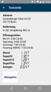
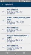
- POI search
- Destination selection directly on the map
- Entry of destination coordinates and crossroads
- Destination selection from a list of recent destinations and from the favorites list
- Use of contacts in the address book as destinations
Navigation:
- Profiles for car, pedestrians, recreational vehicles and caravans
- Adjustable routing: quickest, shortest
- Voice-guided navigation
- Spoken street names through text-to-speech
- Sinage display (motorway signs)
- Speed-dependent zoom and crossroad-zoom
- Stretch-block: Automatic route recalculation (e.g., for the next 0.5-10 km along the route to avoid a traffic jam)
- Avoidance of motorways, ferries, and tollways
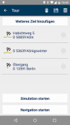
- Itineraries: Management of intermediate stops, saving and loading of itineraries
Map Display and Functionality
- View modes: 3D, 2D in the direction of travel, 2D North up
- Daytime and nighttime view modes, automatic switching (geodaylight)
- Route overview
- Display of POIs with setting of the destination directly from a POI icon on the map
CONDITIONS OF USE:
V-Navi may be used free of charge for a test period of 30 days. Numerous applications, such as the telephone directory apps "Das Telefonbuch" and "Das Örtliche" provide you with the means of continuing to use V-Navi free of charge by starting V-Navi directly from within the apps. Please consult the Conditions of Use in each of the respective apps.
The traffic data to 30 days (trial period) are free to use and are then as in-app purchase.
AVAILABLE in-app purchase options (for pricing, see under "In-App Purchases"):
- Traffic data for Germany (INRIX)
- Navigation und maps for Germany, Austria, and Switzerland (D-A-CH)
- Navigation und maps for Western Europe
The map data and navigation for Western Europe cover the following countries:
Germany (D),Austria (A),Switzerland (CH),Liechtenstein,Andorra,Belgium,Denmark,Finnland,France,Great Britain,Ireland,Italy,Luxemburg,Monaco,Netherlands,Norway,Portugal,San Marino,Spain,Sweden
See more at https://www.facebook.com/Map-and-Route-1454577274845960/
V-导航 - 为Android全功能的导航应用程序,为您带来更快地你的目标!可与各种应用程序(例如,“达斯Telefonbuch”,“达斯Örtliche”,等等),甚至是免费的,随着条件的可申请一起选择。
注意:导航在德国,奥地利,瑞士开始,在西欧可选。
凭借高品质的流量,你会得到市场的完整概述。交通拥堵交通拥塞避免。 V型导航:你会因此总是最好的路线。交通密度显示为红色,黄色,绿色在地图上。德国,年度,自由与没有义务负责购买30天。需要连接互联网。
V-导航的新版本地图板外(有限功能)的作品,使下载后立即导航。德国,奥地利和瑞士的地图数据是在第一次使用V-导航(约300 MB)的开始下载一次。此后,Internet连接只在APP-启动时间短必要的。
强调:
- 德国(Inrix公司)目前的交通状况,路况报导交通拥塞避免和交通密度显示屏
- 第一次安装后离车向量模式
- 车道信息助手
- 现实视图(现实像在高速公路上转弯动作显示)
- 地图数据被存储在设备上
- 快速目的地输入(地址,兴趣点(景点),收藏夹等)
- 更新免费
- 计算与替代路线的显示器
- 限速和超速警报显示
- 纵向和横向显示支持
- 快速菜单
- 新的,符合人体工程学菜单
- 优化的地图视图
- 保存和负载行程
功能:
目的地条目:
- 随着城市的自动弹出列表等地址输入
- 按国家地址搜索
- 众议院数精确地理编码时在线
- POI搜索
- 目的地选择直接在地图上
- 目的地的输入坐标和十字路口
- 最近的目的地列表,并从收藏夹列表选择目的地
- 在地址簿中的目的地使用的联系人
导航:
- 型材汽车,行人,休闲车和大篷车
- 可调节路由:最快,最短
- 语音导航
- 通过文本到语音说出街道名称
- Sinage显示(高速公路标志)
- 速度依赖变焦和十字路口变焦
- 拉伸块:自动路线重新计算(例如,对于沿着路由的下一0.5-10公里,以避免交通堵塞)
- 高速公路,轮渡和收费公路的回避
- 航程:中途停站的管理,保存和行程的负荷
地图显示和功能
- 查看模式:3D,2D的行驶方向,2D北起来
- 白天和夜间视图模式,自动切换(geodaylight)
- 路线概览
- POI显示直接从地图上的POI图标目的地的设定
使用条件:
V-导航可以在30天的测试期内免费使用的。众多的应用程序,如电话簿应用“达斯Telefonbuch”和“达斯Örtliche”为您提供继续使用V-导航直接从应用程序内开始V-导航免费的手段。请参考使用条件中的每个相应的应用程序。
交通数据为30天(试用期)是免费使用,并然后根据应用程序内购买。
可用应用程序内购买选项(定价,请参阅“应用内购买”):
- 德国交通数据(Inrix公司)
- 德国,奥地利和瑞士导航地图UND(D-A-CH)
- 导航地图UND西欧
西欧的地图数据和导航覆盖下列国家:
德国(D),奥地利(A),瑞士(CH),列支敦士登,安道尔,比利时,丹麦,Finnland,法国,英国,爱尔兰,意大利,卢森堡,摩纳哥,荷兰,挪威,葡萄牙,圣马力诺,西班牙,瑞典
更多信息请访问https://www.facebook.com/Map-and-Route-1454577274845960/

V-Navi - APK信息
APK版本: 4.9.7程序包: de.mapandroute.android.vnavi同类应用
您可能还会喜欢……


